


34-La Liviniere : Les Lauziès-16/03/2014

Jovila
User
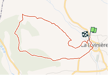


1h24
Difficulty : Very easy

FREE GPS app for hiking
 SityTrail
IGN / Geographical institutes
SityTrail Plus
The world is yours!
About
Trail Walking of 5.5 km to be discovered at Occitania, Hérault, La Livinière. This trail is proposed by Jovila.
Description
Se garer au parking à la sortie à la du village. Prendre la route goudronnée de suite à droite. Suivre le balisage jaune.
Belle promenade avec de magnifiques murets en pierres sèches et capitelles.
Beaux points de vues.
Positioning
Comments